Magnetic Declination Explained: Why Your Compass Doesn't Point to True North
A compass doesn't point to true north, and a map's grid lines don't either — there are three real 'norths' to reconcile. The verified math behind all three.
Magnetic Declination Explained: There Are Actually Three Norths
A compass doesn’t point to true north. Neither, in most places, does the grid printed on your map. There are genuinely three different “norths” in navigation and surveying, and reconciling them correctly — not just knowing they exist — is what keeps a bearing from putting you somewhere you didn’t intend to go.
True North: The Fixed Reference
True north (also called geodetic or geographic north) is the direction along a meridian toward Earth’s rotational axis — the actual North Pole. It’s fixed and doesn’t depend on your local magnetic environment or which map projection you’re using. It’s the reference every other “north” gets measured against. Calculate a true bearing directly between two coordinates with the Azimuth Calculator.
Magnetic North: Where the Compass Actually Points
A compass needle follows Earth’s magnetic field, and that field isn’t aligned with the rotational axis — nor is it static. The magnetic pole genuinely drifts over years (a phenomenon called secular variation), which is why declination values on old maps can become measurably wrong over time. The current authoritative reference is the World Magnetic Model (WMM2025) — released December 2024, valid for 2025.0 through 2030.0, and jointly developed by NOAA’s National Centers for Environmental Information and the British Geological Survey as an official product of the US National Geospatial-Intelligence Agency and UK Defence Geographic Centre. Magnetic declination is simply the angular difference, at a specific location and date, between true north and magnetic north. Calculate it — along with annual change and inclination — using WMM2025 with the Magnetic Declination Calculator.
Grid North: The Map’s Own North
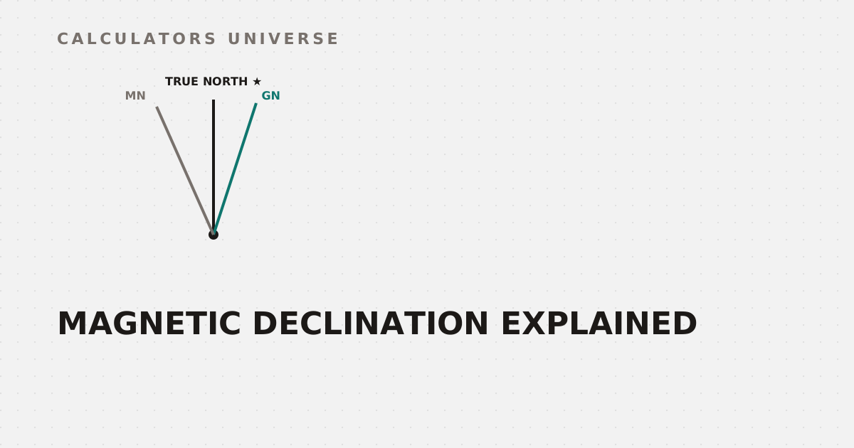
Here’s the “north” most people never learn about: grid north, the direction the north-south lines of a UTM or MGRS grid actually point on a printed map. Because a flat map is always a projection of a curved Earth, those grid lines only align exactly with true north along one specific line in each zone (its central meridian) — everywhere else in the zone, grid north diverges from true north by a small angle called grid convergence. This is a real, separate source of angular error from magnetic declination, and it’s why USGS topographic maps print a three-arrow declination diagram at the bottom of the sheet rather than just one correction value.
True north (★), Grid north (GN), and Magnetic north (MN) — all three genuinely differ
Calculate the exact grid convergence angle and local UTM scale factor for any coordinate with the UTM Grid Convergence & Scale Factor Calculator.
Working in Different Angular Units
Field navigation and artillery work often use NATO mils instead of degrees — a circle divided into 6,400 mils rather than 360 degrees, chosen specifically because it gives finer angular resolution using whole numbers instead of decimals for small-angle adjustments at range. Surveying occasionally uses grads/gons (400 per circle) as well. Convert between all three systems with the Mils to Degrees to Grads Converter.
A Second Way to Find True North: The Sun
When a compass can’t be trusted — near vehicles, power lines, or ore deposits that distort the local magnetic field — there’s a completely independent way to establish true north: the sun’s position. Since the sun’s true azimuth at a given moment is purely a function of location, date, and time (not local magnetism at all), a precise solar position calculation gives a magnetic-interference-free cross-check on direction. Calculate solar azimuth and elevation for any coordinate, date, and time with the Solar Angle Calculator.
Frequently Asked Questions
What’s the difference between magnetic declination and grid convergence?
Declination is the angle between true north and magnetic north, caused by Earth’s magnetic field. Grid convergence is the angle between true north and a map’s grid north, caused entirely by projecting a curved Earth onto a flat map — they’re two separate error sources that both need correcting for.
Why does magnetic north change over time?
Earth’s magnetic field is generated by fluid motion in the outer core, which shifts gradually — a phenomenon called secular variation — moving the magnetic pole and changing declination values at any fixed location over years.
What is WMM2025?
The World Magnetic Model 2025, the current official reference model for Earth’s magnetic field, valid from 2025.0 through 2030.0 and jointly maintained by NOAA and the British Geological Survey.
Why do topographic maps show three north arrows instead of one?
Because true north, magnetic north, and grid north are three genuinely different directions at most locations — a single correction value can’t account for all three relationships at once.
Can I find true north without a compass?
Yes — the sun’s position at a known date, time, and location gives a true azimuth reference completely independent of magnetic interference, historically used as the shadow-stick method and now calculable precisely with solar position formulas.
Related Calculators
Start with the Magnetic Declination Calculator for WMM2025-based compass correction, check the separate grid convergence error with the UTM Grid Convergence & Scale Factor Calculator, and compute true bearings directly with the Azimuth Calculator. Convert angular units with the Mils to Degrees to Grads Converter, and cross-check direction independently of magnetism with the Solar Angle Calculator.
External Resources
- World Magnetic Model — NOAA NCEI — official WMM2025 reference and documentation
- What is declination? — USGS — official USGS explanation of declination diagrams on topographic maps