Flood Zone Elevation and Drainage Catchment: The Math Behind Flood Risk Maps
Flood maps hide a real datum trap: your GPS elevation isn't the one FEMA uses. The real math behind BFE, freeboard, the geoid conversion, and runoff estimation.
The Real Math Behind Flood Risk Maps
A flood zone map looks like a simple colored overlay, but underneath it is a specific chain of calculations — regulatory flood elevations, a genuinely easy-to-miss elevation datum trap, and rainfall-runoff estimation — that decides whether one particular structure is actually at risk.
Base Flood Elevation: The “100-Year Flood” Isn’t What It Sounds Like
The Base Flood Elevation (BFE) is the water surface elevation of the flood that has a 1% chance of being equaled or exceeded in any given year — commonly called the “100-year flood,” a label that misleads a lot of people into thinking it happens once every hundred years. It doesn’t; it’s a 1-in-100 annual probability, meaning it could plausibly occur in consecutive years. FEMA determines BFEs through hydrologic and hydraulic modeling and publishes them on Flood Insurance Rate Maps (FIRMs).
Freeboard: The Safety Margin Most People Miss
Freeboard is additional elevation built above the BFE as a safety buffer against the many things a flood model can’t fully capture — wave action, bridge and culvert effects, and the watershed’s changing hydrology as an area urbanizes. FEMA recommends a minimum of 1 foot of freeboard, though many local jurisdictions require 1 to 3 feet or more. Communities participating in the National Flood Insurance Program (NFIP) require a new or substantially improved structure’s lowest floor to sit at or above the BFE. Check your structure’s elevation, BFE, freeboard, and NFIP compliance together with the Flood Zone Elevation & Freeboard Calculator.
The Hidden Datum Problem: Why Your GPS Elevation Can Lie to You
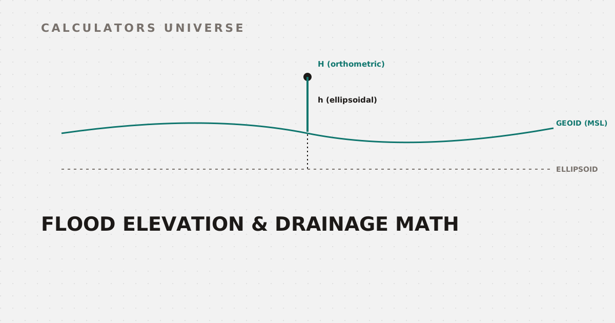
Here’s the trap that catches even careful people: a consumer GPS or GNSS receiver naturally reports ellipsoidal height — elevation measured against a smooth mathematical surface (the WGS84 ellipsoid), not against sea level. FEMA’s flood elevations, however, are referenced to an orthometric height datum (like NAVD88), which follows actual mean sea level and the Earth’s real, uneven gravity field. The difference between the two, called the geoid undulation (N), can be tens of meters depending on location — and the conversion is a genuinely simple formula that’s easy to skip by accident:
Skipping this conversion can make a structure appear above BFE when it's actually below it, or vice versa
The formula is H = h − N, where H is orthometric height (what FEMA maps use), h is your GPS’s raw ellipsoidal height, and N is the geoid undulation for that location. Convert correctly with the Geoid Height Calculator before comparing any GPS-derived elevation against a published BFE.
Estimating the Water That Actually Arrives: The Rational Method
Flood risk isn’t just about a fixed elevation — it depends on how much water a storm actually delivers to a given catchment. The Rational Method, still the standard for small drainage areas, estimates peak runoff as Q = C × i × A: in US units, Q in cubic feet per second, C a dimensionless runoff coefficient (reflecting land cover, soil type, and slope — pavement runs off very differently than forest), i the rainfall intensity in inches per hour, and A the catchment area in acres. In metric units, Q = 0.00278 × C × i × A, with Q in m³/s, i in mm/hr, and A in hectares. The method is generally considered reliable only for smaller catchments, typically under about 200 acres.
Peak discharge at the outlet depends on the entire catchment's area, cover, and rainfall intensity
Estimate peak stormwater discharge for your own catchment with the Rational Method Calculator.
What Happens With the Excess: Earthwork and Detention
Once peak runoff is estimated, managing it often means constructing detention ponds, levees, or regrading a site to redirect water safely — all of which come down to cut-and-fill earthwork volumes. Calculate those volumes using the average end area or prismoidal method with the Earthwork Cut & Fill Volume Calculator.
Reading the Terrain That Feeds the Model
Catchment delineation and runoff timing both depend on the terrain itself. Check slope directly from a DEM with the DEM Slope & Aspect Calculator, or work from a topographic map’s contour spacing with the Contour Interval Calculator to understand the gradient feeding water toward a catchment’s outlet.
Frequently Asked Questions
Does “100-year flood” mean it only happens once every 100 years?
No — it means a 1% chance of occurring in any given year, which is a meaningfully different (and less reassuring) statement than “once a century.”
Why does freeboard matter if a structure is already above BFE?
Because BFE itself doesn’t capture every real-world factor — wave action, obstructions, and changing watershed conditions can all push actual flood levels above the modeled BFE, which is exactly what freeboard is meant to buffer against.
Why might my GPS elevation not match a flood map’s BFE?
Because your GPS likely reports ellipsoidal height (relative to a mathematical model of Earth’s shape), while FEMA’s BFE uses orthometric height (relative to mean sea level) — the two can differ by tens of meters depending on location unless you apply the geoid height conversion.
What is the Rational Method actually used for?
Estimating peak stormwater runoff discharge from a catchment for storm sewer and small drainage system design — it’s a quick, standard first-pass calculation, not a full hydrologic model.
Is the Rational Method accurate for large watersheds?
Generally not recommended — it’s considered reliable mainly for smaller catchments, typically under about 200 acres, where rainfall intensity and land cover can be reasonably treated as uniform.
Related Calculators
Check compliance and safety margin with the Flood Zone Elevation & Freeboard Calculator, and make sure any GPS-derived elevation is converted correctly with the Geoid Height Calculator first. Estimate peak runoff with the Rational Method Calculator, size any resulting earthwork with the Earthwork Cut & Fill Volume Calculator, and read the terrain driving it all with the DEM Slope & Aspect Calculator and Contour Interval Calculator.
External Resources
- Base Flood Elevation (BFE) — FEMA — official FEMA glossary definition and regulatory context
- GEOID18 — National Geodetic Survey — NOAA’s official geoid model used to convert GNSS ellipsoidal heights to NAVD88 orthometric heights